
The Charleston peninsula is a preservationist’s muse, and the area’s chronology is evident at every turn. Home to one of the largest and best preserved Historic Districts in the nation, the entire downtown area is deemed a National Historic Landmark. We teamed up with The Charleston Museum, America’s first museum, to take a look back at a few of our favorite iconic spots in Charleston. Scroll on to explore Charleston then and now.

Lovingly referred to as Rainbow Row, the thirteen frequently photographed homes that stretch from 79 – 107 East Bay Street look like a watercolor painting and are an indelible part of Charleston’s character. In 1932, homeowner Dorothy Porcher Legge dreamed up an idea to beautify her street: fresh coats of paint in a variety of Caribbean colors. The first home to receive a pastel-hued facelift belonged to Legge, who gave 99 – 101 East Bay Street a pretty pink facade. Each of the neighboring homes soon embraced a signature color, including shades of yellow, green and blue. See more of our favorite photo-op spots in Charleston.
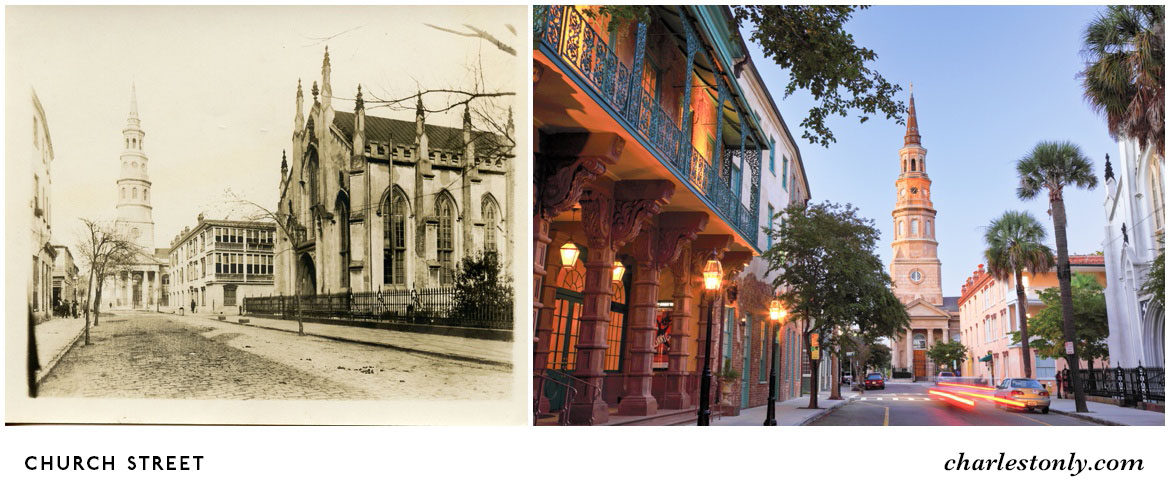
Established in 1670, St. Philip’s Episcopal Church originally stood on the site where St. Michael’s Episcopal Church stands today. The second structure at the present site was completed in 1724 but was destroyed by a devastating fire in 1835. During the Civil War, St. Philip’s bells were converted into cannons, but on July 4, 1976, new bells were placed in the steeple and St. Philip’s was known as the lighthouse in the Holy City. In St. Philip’s churchyard are the graves of John C. Calhoun, Secretary of War and Vice President of the United States; Edward Rutledge, signer of the Declaration of Independence; Charles Pinckney, signer of the Constitution; and Dubose Heyward, author of “Porgy.” View more of Charleston’s historic Houses of Worship.

The first bridge to cross the Cooper River was constructed in 1929. Holding the title of fifth longest bridge in the world, the structure was 1,050 feet long and soared 150 feet above the river. The bridge has since been replaced with the Arthur Ravenel Jr. Bridge, the longest cable-stayed bridge in North America. Towering approximately 18 stories above the Cooper River, the 2.5-mile pedestrian path flanking the bridge is among the Charleston area’s most spectacular vantage points. Discover 13 more spots to get your 10,000 steps in Charleston.

While enjoying a walk along East Bay Street, keep your eyes open for a green street sign labeled “Stoll’s Alley,” or you may just miss this charming, hidden brick passageway. Stoll’s Alley was once known as “Pilot’s Alley,” a nod to the nearby maritime scene, and was later named for Justinus Stoll, the builder and homeowner of 7 Stoll’s Alley. Explore 8 secret alleyways in Charleston.
Want to learn more about Charleston’s deep-rooted history? Check out the 21 spots every history buff must visit in the Lowcountry.


